SNA Frontpage
-Thematic MapsSNA Map of Sweden at a scale of 1:700,000Facts about Counties and Municipalities

Other maps: To bottom of page

Traditional Provinces

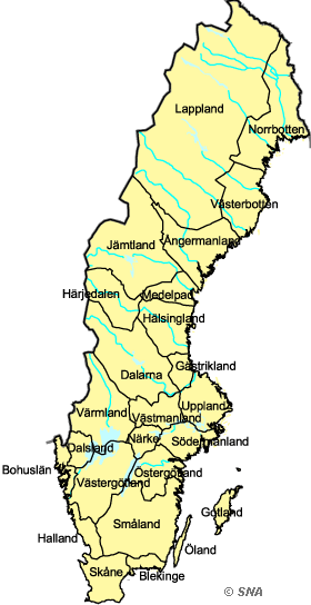
Map of Traditional Provinces


Traditional Provinces
Although the division of the country into provinces (landskap) has had no administrative function since medieval time, they are still the basis for regional identity (except for the northernmost part of the country where the later �l�ns�-division has taken over). Since the 16th century the provinces have their coats of arms, today province flowers, animals and minerals have been added. The provinces were established in prehistoric time. In the Middle Ages they maintained much independence with their own laws, judges and �parliaments� (landsting). The elected king of Sweden had to be confirmed by each province until Gustav Vasa introduced the hereditary kingdom in 1544.

See also ' Traditional Regions'


Source: National Land Survey
Based on the printed version of The National Atlas of Sweden:
Book : The EUGEO Selection (about the book)
Chapter: 1 The State and the Country
Section: 1.2 The Building of the Territory


Choose another theme (set of maps):

Search among the map titles:

Select other maps on
The EUGEO Selection (60 maps)

-
Read more about SNA or send email to [email protected].
Dynamically created 2006-09-25 using template updated 2003-04-07.