
|
|
|
|
The railway network, 1876 |
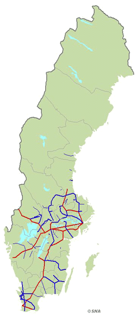 |
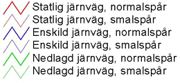 THE HISTORICAL RAILWAY NETWORK The Swedish railway network was at its peak in the late 1930s. The main lines were built with a standard gauge of 1.435m, while the private railways often used narrow-gauge track; 4,000km of a total of 17,000km was narrow-gauge track. The maps show the railway connections between towns, not the exact track routes. Read more about the historical railway network.
Source: Railway data 1999, The Railway Club I samma kartserie ing�r:
The railway network, 1876 The railway network, 1906 The railway network, 1936 The railway network, 1966 The railway network, 1996 |
|
Based on the printed version of The National Atlas of Sweden:
|
|
Choose another theme (set of maps):
Search among the map titles:
|
Select other maps on
The Infrastructure (88 maps) |
|
Read more about SNA or send email to
[email protected].
Dynamically created 2006-09-25 using template updated 2003-04-07. |
